Back Onkaparinga CEB Onkaparinga City German Ville d'Onkaparinga French Città di Onkaparinga Italian City of Onkaparinga Dutch City of Onkaparinga Polish Onkaparinga Swedish 安加白令嘉市 Chinese
| City of Onkaparinga South Australia | |||||||||||||||
|---|---|---|---|---|---|---|---|---|---|---|---|---|---|---|---|
 | |||||||||||||||
| Population | 175,204 (LGA 2021)[1] | ||||||||||||||
| • Density | 338/km2 (880/sq mi) | ||||||||||||||
| Established | 6 March 1997[2] | ||||||||||||||
| Area | 518.4 km2 (200.2 sq mi) | ||||||||||||||
| Mayor | Moira Were AM[3] | ||||||||||||||
| Council seat | Noarlunga Centre | ||||||||||||||
| Region | Southern Adelaide[4] | ||||||||||||||
| County | Adelaide[5] | ||||||||||||||
| State electorate(s) | Davenport, Finniss, Fisher, Heysen, Kaurna, Mawson, Mitchell, Reynell | ||||||||||||||
| Federal division(s) | Kingston, Mayo | ||||||||||||||
 | |||||||||||||||
| Website | City of Onkaparinga | ||||||||||||||
| |||||||||||||||
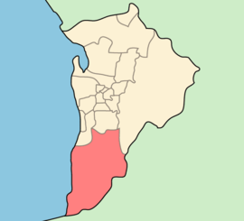
The City of Onkaparinga (/ˌɒŋkəpəˈrɪŋɡə/) is a local government area (LGA) located on the southern fringe of Adelaide, South Australia. It is named after the Onkaparinga River, whose name comes from Ngangkiparinga, a Kaurna word meaning women's river. It is the largest LGA in South Australia, with a population of over 170,000 people in both urban and rural communities and is also geographically expansive, encompassing an area of 518.3 km2. The council is headquartered in the Noarlunga Centre with area offices situated in Aberfoyle Park, Woodcroft and Willunga.
- ^ Australian Bureau of Statistics (28 June 2022). "Onkaparinga (Local Government Area)". Australian Census 2021 QuickStats. Retrieved 28 June 2022.
- ^ Wotton, D. C. (6 March 1997). "LOCAL GOVERNMENT ACT 1934 SECTIONS 7, 8, 11 AND 14: ALTERATION OF BOUNDARIES—AREAS OF THE DISTRICT COUNCIL OF WILLUNGA AND THE DISTRICT COUNCIL OF PORT ELLIOT AND GOOLWA —AMALGAMATION OF THE CORPORATION OF THE CITY OF HAPPY VALLEY, THE CORPORATION OF THE CITY OF NOARLUNGA AND THE DISTRICT COUNCIL OF WILLUNGA" (PDF). The South Australian Government Gazette. Government of South Australia. pp. 1110–1114. Retrieved 1 February 2019.
- ^ "Elected Members". City of Onkaparinga. Retrieved 7 February 2023.
- ^ "Southern Adelaide SA Government region" (PDF). The Government of South Australia. Archived from the original (PDF) on 27 March 2019. Retrieved 17 April 2017.
- ^ "Search result for "County of Adelaide, CNTY" with the following data sets selected - "Counties" and "Local Government Areas"". Property Location SA Map Viewer. Government of South Australia. Retrieved 24 April 2017.
© MMXXIII Rich X Search. We shall prevail. All rights reserved. Rich X Search